Working Prototype — Industry Validation Underway
The Hidden Problem in Maritime Operations
Maritime operations depend on information from many different sources — equipment, drawings, manuals, maintenance records, checklists, surveys, inspections and operational systems.
The challenge is not always a lack of information. The challenge is being able to see, understand and act on the right information at the right time.
Spatial Awareness
Important equipment, systems and their physical relationships can be difficult to understand through conventional drawings, documents and disconnected screens.
Information Context
Critical operational information is often distributed across maintenance records, procedures, checklists, reports, surveys and different systems.
Decision Clarity
Even when information exists, teams may still need to determine what it means, what to check, who should act and whether the required action has been completed.
Maritime3DOrbis brings these layers together in one visual, interactive environment.
From Physical Assets to Visual Intelligence
Maritime3DOrbis connects the physical maritime environment with the information needed to operate, maintain and manage it.
👁️ See
Visualise vessels, equipment, pipelines, seabed and operational environments through interactive 3D models.
🧩Understand
Connect physical assets with technical information, maintenance history, procedures, inspections, checklists and operational context.
📡Monitror
Bring together live and historical information from sensors, telemetry, alarms and operational records.
✓ Act
Help the responsible person understand what needs attention, what action is required and whether it has been completed.
The goal is not simply to create a 3D model. It is to connect the physical asset with the information and actions required to operate it.
Working Prototype
Our current prototype demonstrates how maritime assets, spatial data and operational information can be brought together through a browser-based interactive environment.
Interactive Equipment Visualisation
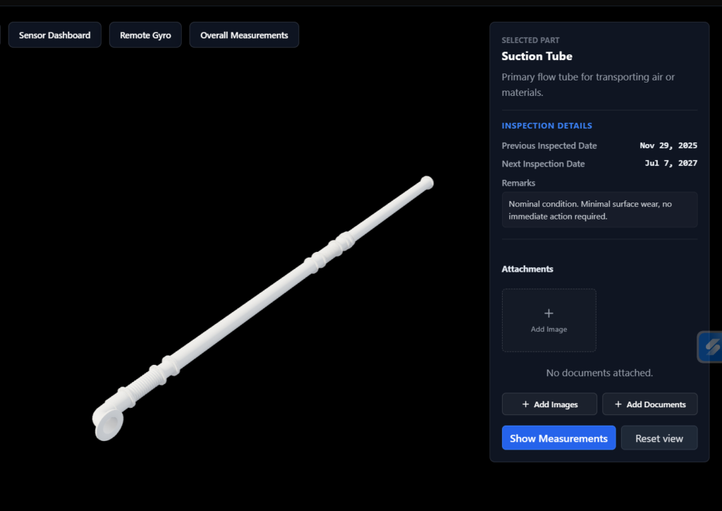
Explore maritime equipment such as suction pipes and dragheads through interactive 3D models.
Visual Bathymetry & Survey
Visualise seabed and survey-derived environments in an interactive 3D space, with vessel movement and water-level changes demonstrated in the prototype.
Mobile 3D Interaction
Demonstrating how mobile device sensors such as the gyroscope can interact with a browser-based 3D maritime model.
Equipment & Operational Information
Demonstrating how technical information can be connected to physical equipment within an interactive visual environment.
Visual Maritime PLM
Put Operational Information Where the Asset Is
Maritime equipment is supported by information spread across maintenance records, technical documents, inspection checklists, procedures and operational systems.
Maritime3DOrbis aims to connect this information directly to the physical asset through an interactive 3D environment — making it easier to find, understand and act on the information that matters.
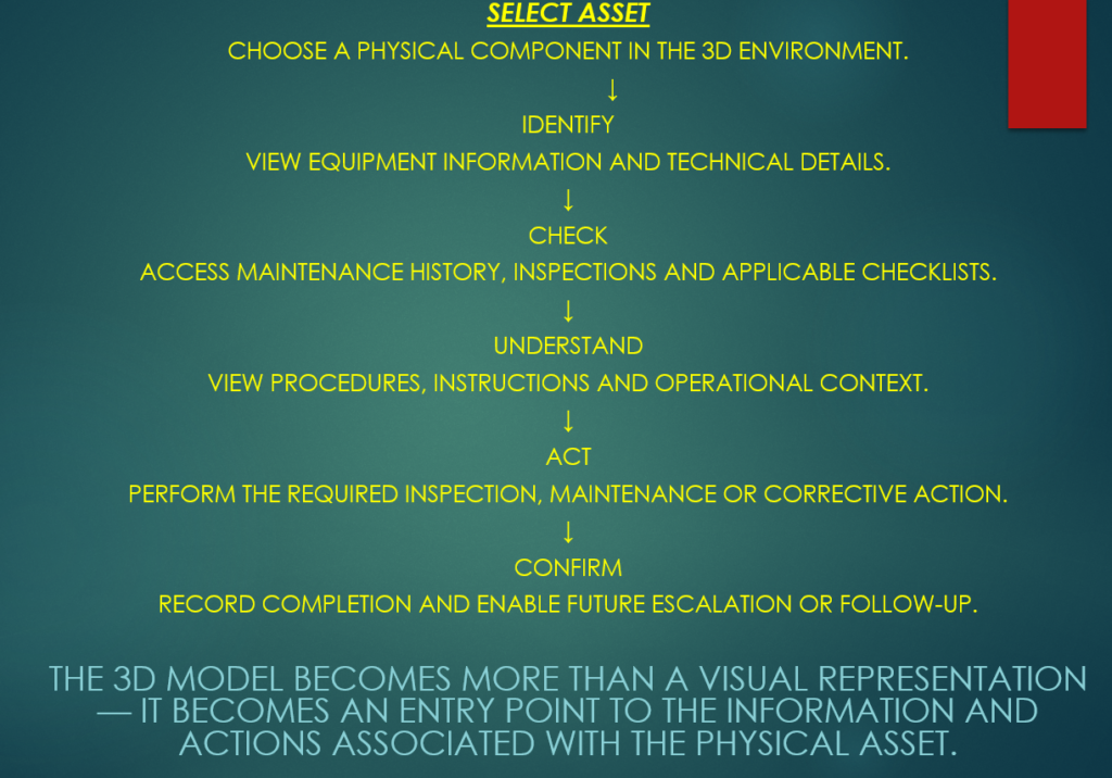
The 3D model becomes more than a visual representation — it becomes an entry point to the information and actions associated with the physical asset.
From Information to Operational Awareness
Critical information may already exist onboard — in alarms, procedures, checklists, inspection records and technical documents. The challenge is making that information visible, understandable and actionable when it matters.
ALARMS & PROCEDURES:
Know What the Alarm Means:
An alarm should not only indicate that something has changed. The responsible person should be able to understand the equipment involved, what needs to be checked, what action is required and whether the action has been completed.
CONDITION & SYSTEM MONITORING
See System Condition:
Future sensor integration can connect selected equipment and system conditions to the visual environment, helping teams identify abnormal conditions and respond before they become operational consequences.
INSPECTION & COMPLIANCE:
Make Required Checks Visible
Digital, editable checklists can bring inspections, procedures and assigned responsibilities into one environment, helping reduce missed checks and making outstanding actions easier to follow up.